Wednesday, January 11, 2017

Dry Ice: The MOST Hidden Danger of Winter

 Dry ice - we are all familiar with it.  Typically we see it at 80's tribute band concerts and high school plays.

When dry ice is indoors, it's controlled...and safe
However, that's not the dry ice gaining attention this winter season.  Like it's cousin, black ice, dry ice is difficult to spot.  Black ice appears as slick wet pavement, but is in fact a thin layer of frozen horror.

Dry ice is even more difficult to see.  It appears as a completely dry road surface.  The only thing that makes it noticeable at all is the extreme caution drivers use when going over it.  So the next time you are caught in slow moving winter traffic, and there seems to be no apparent reason for it, don't get angry.
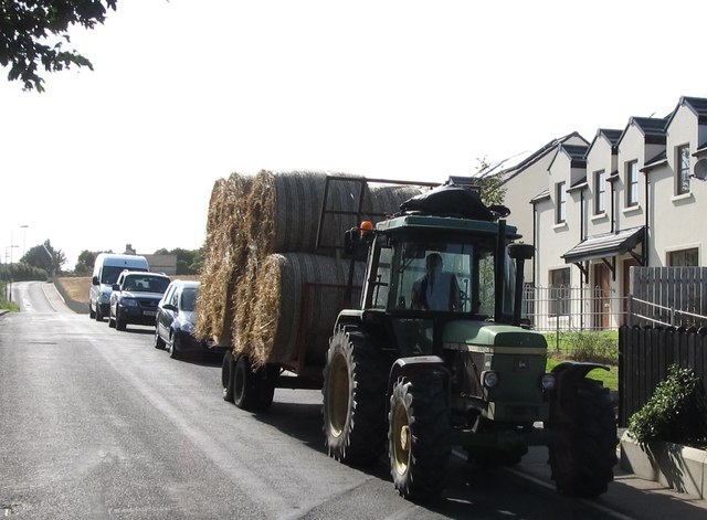
Some communities now use farm vehicles or even horse and buggy to lead the way in the crusade against dry ice.

 Instead, be grateful that someone up ahead discovered the dry ice and slowed to a safe speed, ensuring you and other motorists don't slide wildly off the side off what appears to be a completely dry and normal road surface.

Have you encountered any dry ice?  Let us know and we will tweet out warnings.  Remember, we are all in this together.

As always, the Chester County Weather Insider is ahead of the curve, bringing cutting edge coverage of stories that matter.  

Friday, January 6, 2017

Helena Arrives With Little Warning, and Even Less Impact

Helena arrived in Chester County with very little fanfare on Thursday evening, and after a few hours we kind of saw why.  This event was really only significant for a handful of reasons:

  1. It was the first snow of 2017
  2. It was the first system responsible for a delay at AGSD
  3. It allowed CCWI to implement new FB Technology and begin true Go-Cam Live Footage and narratives (for better or worse.)
Helena managed only a 1.2 on the WAIF


"The system was relatively weak as it approached on Thursday, and limped along in a predictable fashion allowing us to get the roads treated before she arrived," said  Tim Grabowski, at ChesDOT.  "After about 4 hours of continuous snow, the NWS was still only predicting snow at an 80% likelihood, which is a good indication of what little power this system packed.  Like when we were kids, and our little brother was hitting us and we pretended not to notice..."

Snow covered the ground and the NWS still only gave Helena an 80% chance of amounting to anything. #itsamansworld


However, by time the storm was over, she had left her mark.  A tricky dusting of flakes and spots of ice in corn fields and on ponds had local schools taking no risks, delaying the start of classes for 2 hours.  

We sent our West Grove Correspondent out this morning, during the morning rush, and while the roads were clear and safe, the same could not be said of social media, where he was shamed for not thoroughly cleaning snow off his hood and windshield.  

The Insider takes aim at social media shamers.

Investigations later revealed that the snow amounts on the hood of the car were exaggerated by the camera angle and proximity in the windshield mount, and a reckless situation had not taken place.  Despite that, we are told our correspondent went to Lowe's immediately after work to invest in a high tech snow and ice scraper for future events.


Saturday, September 3, 2016

Couple Braves Hermine and Visits the Nota Republic!

Despite cloudy skies and moderate temperatures, we set out to head south towards the threat of Hermine and spend part of our Labor Day weekend in the Nota Republic.

The skies looked a tad intimidating but our spirits were not dampened.  We checked the forecast and felt it offered us a window to make it happen.

Our spirits never dampened as we headed out, until we got there.  While I was aware that this was primarily a business trip, I still hoped a chance to visit a remote land would afford some photo ops and maybe even an exotic meal or two.  

A few years back, my trip to the Dominican Republic was just wonderful.  This year's trip to the Nota Republic was in comparison, a disappointment.

While the people from both republics were very friendly and accommodating, the overall impact of the Dominican was far superior.   However, our entire trip to the Nota Republic only cost us 5 dollars, plus 35 cents for gas.  I guess it's true.  You get what you pay for.

The best photo ops occurred on our way home, at Lowes.  Here we see the weather control system they use to keep the bad weather out and let the good weather in.  Here in the business we refer to this as an Atmospheric Scrubber.

As we headed back north, skies cleared and we reflected on our time at the Nota Republic - definitely worth it for business but not exactly a "destination", especially when tropical weather threatens.  

The good news is you do not need to worry about travel insurance, as the costs are so reasonable.


Thursday, January 21, 2016

Reptile Concerns Accompany Jonas


Winter storm Jonas is ramping up to become the event of the year in the Mid-Atlantic.  Granted blockbuster status earlier this week, and added honorary Jonas brother credentials, the storm has all the makings of a "celebrity to be".

However, it's not all smiles and sunshine.  The National Weather Service has issued a Lizard Warning from Friday through Sunday.  


It seems the cold temperatures and snow would be dangerous for these cold blooded species.  We asked Art Beckman, herpetologist from the Philadelphia Zoo why he felt a lizard warning was issued and not a snake warning.  He explained,"while this IS an unusual warning, I can only imagine it's the legs and toes issues.  Lizards have legs and toes.  They are much more susceptible to frostbite and winter related set backs.  Snakes are all core, and the core is the last part of the body to be affected."


Signs that your reptile may be suffering and need a warm rock and sun would be a loss of color, irritated look, and deformed toes, as the above example illustrates.

As people prepare for the weather, we sent our staff photographer out this morning and he was able to visit about 35 grocery stores in the area, and photograph what we believe are the last of the milk, bread and eggs that our region will see until late Monday.


We will continue to monitor the situation and keep you updated as Jonas makes its way into the area.


Tuesday, January 19, 2016

Chester County in the Bulls-eye? Some Models Say Yes!

Chester County residents are bracing for what could be the biggest snow event of the season, making recent events look like trivial dustings...which they were.  This weekend things are in place for a winter storm to be named later to develop and ravage the mid-atlantic before heading up the east coast and developing into a Nor'Easter.

We at the Insider know it is hard to really take a winter storm seriously until it has a name.  But don't be lulled into complacency by the anonymity of this little low pressure devil.

As things set up, the two most reliable weather models show slightly different forecasts, but both spell significant snow for our region.

Sally, the US GFS Weather Model had this to say:


"Well, so far it's been like, uh, pretty mild, but now it's cold, and when that happens the rain we normally get freezes and becomes snow.  And I drew this map and I say the bulls-eye is like right here, to the west of philly."


Sally is predicting a total of 2-3 feet for our area, the highest of any place on the east coast.

Other models feel that the storm will be a little stronger to the south and west.


Ulf, our European model had this to say:

"Vee sink zee storm shall be more strong a bit to zee lower states.  Eet is in ziss areas zat zee totals will exceed 90 cm, or as you say 3 ft."


Even Ulf feels Chester County could see 12-18 inches.  Avongrove Schools have already scheduled an inservice day on Monday, so students can sled their way to stores and get any bread or eggs that their parents forgot to get Thursday.  "We consulted the Farmer's Almanac last year and knew we were in for a doozy," said Ernie Sneed, head of transportation.


Wednesday, January 13, 2016

Winter Squall Alice Rocks Chester County

Our first significant weather event whipped up yesterday afternoon and into the night. The warm generous Mother Nature that had cared for us this winter season turned her back on us, and then released her wrath.


This was the scene as temperatures plummeted from the low 40s into the lower 40s and finally dipped into the 30s causing many a resident to zipper their coat.

In the evening it worsened as flakes fell from the sky in rapid succession.  We had our top reporters out on the road, and we can report that visibility was slightly decreased by the intensity of what some are dubbing the squall of the century.  However, in a press conference, Washington Redskins owner Daniel Snyder has announced he will call it the squaw of the century.


The squall forced many to use their wipers and defrosters if they braved the conditions. 

Dave Renz reported that many braved the storm to get salt...not sidewalk salt, as much as table salt. Others in the area prepared for the event by buying bread and milk.  Clearly those seeking these sources of processed food and salt on a winter evening are addicted to the poisons that have become staples in the upside down US diet, and should probably read our health blog, Newtritarian.

Field reporter Brian Holden captured the fall out in the southern corner of the county.


The folks in this neighborhood were mostly waiting it out before tackling the remnants of the Squall of 2016.  "We'll have time in the morning to deal with this mess," said Bob Castaldi.

All Chester County Schools are scheduled to be opening on time thanks to the efforts of the communities to clear the streets from the storm's dastardly doings.  However, keep your eyes on the skies... We have a feeling many of you may not be risking a frigid commute on Monday.

Until next storm, be safe and be warm.


Friday, December 25, 2015

Chester County Dreams of Wet Christmas

Christmas 2015 was one for the ages as old man spring reared his ugly head and blasted the region with mild temperatures and warm rain.

While the warm temperature was a blessing for many in the region who have lost weight reading the Insider Inc.'s health blog, "Newtritarian", it created some problems for Santa as he moved through the region.


Just south of the Poconos, our Weather Insider Santa Tracker picked up this troubled Santa at dawn.  However, within a short time some friendly elves in the Warm Weather Troubleshooting Division airlifted in a solution, and in a flash Santa was on his way again.


Santa was able to make his remaining stops in Chester County using this 2 wheleled sleigh, before ditching it when it ran out of gas as he crossed into Jersey.

This unusual Subtropic blast, referred to in serious weather circles as "La Piñata" gets its name from the warm temperatures associated with Cinco de Mayo and the way water dumps from the sky as if a giant Piñata has been bashed over our region.


Santa was able to deal with the warm weather and unusual amounts of water in style - here he is finishing up deliveries along the Black Horse Pike in nearby NJ, humming the beach boy classic "Little St. Nick" and making the most of this year's unusual circumstances.


We at the Insider would encourage you to be safe this holiday season. Check in on elderly neighbors and relatives to make sure none are in danger of heat stroke, and make sure they are staying hydrated.

La Piñata is expected to influence the region for at least a few more weeks.  We will have more updates when our weather models have new information.


Our current model seems to really have no idea what to expect.


Sunday, October 18, 2015

Fall Storm Arnold Ravages Chesco!!!

Fall Storm Arnold Ravages ChesCo!

October 18 was a day to be remembered in the annals of weather lore.  Fall Storm Arnold sprung up out of nowhere and sprinkled water, wind, rain and chilly air on unsuspecting victims from Downingtown to Landenberg.


SCC Correspondent Kathleen Anderson reported back on her experience this afternoon.  "It was cold.  Much colder than yesterday.  And the leaves were being blown right off the trees.  Old Man Fall was really rearing his ugly head today."


Weather watchers reported a hail storm in Downingtown that showered baby pea sized hail down on them for minutes on end.  In the Southwestern portion of the county cold driving rain was observed by Insider staff.  It was a day better spent indoors.  "It snowed on my friend's horse," said an exasperated Sarah Renz.  "This is NOT what I asked for on my birthday."


At this point ALL CHESTER COUNTY SCHOOLS remain OPEN.  Despite the sub 40 degree temps, schools are braving the weather to go on with business as usual.


Thursday, March 5, 2015

Winter Storm Thor Roars Through Early March


Winter Storm Thor is being called the "Winter Lion of March©."  By me.  And now by you.


The storm has already created the largest snow-nut of the season, and it's not done yet.


We all saw this one coming, so there was no reason to hype any forecasts or predictions.  What we couldn't predict was just what kind of impact The Winter Lion © would have.

We at the Weather Insider were forced to do the unimaginable.


Yes, the sheer volume of snow forced us to sleep late and put off reporting for several hours.


The deep snow almost overwhelmed local electric power shovels.  However, persistent efforts eventually allowed snow throwers and the human spirit to prevail.

Perhaps most impressive was the fact that school closings in the area were almost unanimously agreed upon as appropriate. 


Jeb Pyle, long time West Grove resident commented, "Now THIS is what I call snow.  All year long they've talked a good game, but finally they had a reason to close school. A flake here, a flake there, 2 hour delays... Gimme a break ... In MY day that would have been a joke. We had no problem getting to school with our sleighs and snow shoes. This generation is soft.  And school taxes are too high, too."

Local citizens are not the only ones thrilled to have a true weather event to talk about.  Meteorologists are thrilled too.  "It's great!  Finally we got it right!  I would say out low point was when the national discussion turned from storm totals and real feel temperatures to llamas and dress colors.  It's good to be back to talking about the weather," shared a local meteorologist who wanted to remain anonymous for reasons we have yet to figure out.


We have almost doubled seasonal snowfall totals at this point, and according to gr8 4caster™ there is more to come for the next 4-5 hours.  As satellite images show, very little progress has been made, as the storm crawls from west to east.  

Local weather watcher Santi Pizzini found this out the hard way - she was hoping spring was around the corner, but woke to this message on her computer screen:


Meanwhile, our crack team of meteorologists have been scouring maps trying to puzzle out when relief will be in sight.


While the picture is clearing up in the west, the east is still a big muddled mystery.   We will have more as things clear up!  Stay warm and happy weather watching!


Saturday, February 28, 2015

Is THIS Snow White or Blue?

Thursday night, Chester County and surrounding areas were hit hard by a sneak attack of snow. Just 24 hours after a predicted snow did NOT develop into anything, this one came out of nowhere.


In addition to the surprise snow, THIS snow packed an additional surprise.  Some people actually saw the snow as blue.

That's right. We asked a British scientist what he thought (notice his spelling of color).  "It's likely due to some kind of colour constancy illusion, where some people are perceiving the context to be something like "lit by blueish daylight" and others are perceiving it to be something like "under yellow department store lights." In the former case, your brain will try and get the objective (if such a thing can be said) colour by subtracting out the blue as a shadow.  This is a common illusion in psychology but it's not seen that often 'in the wild,' even though your brain does this constantly."

So based on this theory, we at Chester County Weather Insider conclude all snow is actually blue but because we view it in daylight, and not in department stores we see it as white.

So what happened Thursday that allowed some of us to see the snow as blue?  The angle of the sun passing through the clouds perfectly replicated the poor yellow lighting of a typical department store, so those who do not spend hours shopping saw the snow as blue.  Those of you who are shopaholics, your eyes went into autopilot and compensated making the snow appear white as it normally does.


Above we have enhanced the original photo so everyone can see the extreme manner in which this may be perceived. Do your eyes perceive it as it actually IS in the original photo, or did your eyes played tricks on you and allow the snow to look mainly white with only a hint of blue?

Stay warm, and happy weather watching from the Insider!


Sunday, February 22, 2015

Snowmeggadon 5.0 Wreaks Havoc in the Area!

Winter Storm Pandora swept through the mid Atlantic this weekend unleashing a box full of fury.  The snow depths of over three inches makes this officially Snowmegaddon 5.0.


We at the Insider were blessed to not bear the brunt of this wintery assault, yet thanks to our network of snow spotters and crack reporters, we have all the details you need.

While snow spotters have Snowmegaddon 5.0 depths in the 3-4 inch range the Insider Real Feel Snow Depths (tm) were reported at "Holy Cow, that's a lot of snow!"


This is a new index, similar to the wind chill matrix that allows us to indicated what it realllllly feeeeels like out there after major snow events.  The Real Feel Snow Depth (tm) will be accompanied by a picture indicating how you should most appropriately react when looking out at the devastation, or being interviewed by reporters braving the storm.


Staff photographer Felicia Renz sent me a picture of this Snownut late yesterday, which became an ice Glazed Snownut overnight.


Here you can see snow depths significantly deeper than the treads on tires of the clean up vehicles - the first time all year they have had to deal with such conditions.

We at the Insider hope you are all safe, as we will be returning from the heartland early this week! Happy Weather Watching!


Monday, February 16, 2015

Savant Predicts Biggest Snow Fall Totals Yet!

Last week we began tracking this storm, and our models were pretty sure a significant event was in store.  As the week went on our models have not yet reached consensus, but now 8 of 10 feel we will get snow - up from 7 of 10 a week ago.

Meanwhile, we have heard of a child weather savant in Toughkennamon who has accurately predicted all the storms this year within 2 inches.


When staffers at Tommy Tinker's Day Care turned there back, they found this little rascal working out details on this week's storm.  "He was muttering nonsense words like millibars and barometric, and we told him to use his 'big boy' words."

Frustrated, the child (who's name is not being released due to weather privacy legislation - WiPL) grabbed a crumpled up U.S. Map and a red crayon and proceeded to point and say "SNOW! Snow is coming TONIGHT!"


The National Weather Service has issued and Advisory for our area, with an 80% chance of snow, but they have issued a warning for neighboring Newark DE, and Elkton MD.

Because of our proximity to these areas we at CCWI are a issuing a Winter State of Panic.  We are officially calling this Snowmeggadon 4.0 and predicting a snow day for local schools in our area tomorrow.


Sunday, February 15, 2015

Idaho Meteorologist Predicts Frigid Conditions After Forgetting Valentine's Day

While the Northeast is blasted by another polar vortex, most of the Northwest is seeing extremely mild conditions.  However a Meteorologist in Boise Idaho feels that trend will end, locally.


Lionel Myers, A meteorologist at KTVB 7 in Boise experienced a severe drop in temperature that began Saturday morning and continued into the evening.  


Myers explains, "While all weather models indicated a mild weekend, things dipped very quickly beginning Saturday morning.  My wife of 6 months, greeted me with breakfast in bed, and I thanked her, as any good husband would.  I then proceeded with my daily routine as normal.  I read some weather blogs, looked for changes in air mass, and even tweeted out some predictions for the next 5 and 10 day forecasts."  By mid afternoon, as he continued, he noticed the outside temperature rising as the sun moved across the clear blue skies, but inside it was cold and gloomy.

"Finally, around 7pm, Kristen asked me if I had made any dinner reservations.  I gently reminded her that it was the 2nd Saturday of the month, and that means D&D night.  I went over to my buddy Kevin's house...well technically it is his parent's place... he lives in the basement.   I was expecting a great night of slaying ogres.  Kevin looked stunned.  He said he just assumed since it was Valentine's Day I would not be around.   My face was ashen.  It was like I was caught in the midst of a dangerous winter squall."  Myers went into a state of emergency.

"I rushed to the grocery store and grabbed one of the last cards they had,"


After getting the card, he headed over to the flower department.  No staff was on hand, but they did have some flowers leftover, and they came with a vase.


"I texted my wife a Valentine's wish and message to let her know I was on my way home and had planned a dinner for us to enjoy together on our first Valentine's Day as a married couple."  When Myers got home, his wife was apparently locked in the bedroom and said she did not feel good and did not want to come out.  After pleading, and coaxing her out with a promise of a pasta dinner made especially for her, she begrudgingly opened the door.


With dinner prepared and plated especially for the occasion, Myers was sure the arctic blast would move out quickly.  He even opened a bottle of libations he had picked up from the grocery store's meager stock.


"Once dinner was on the table, I unscrewed the wine and said something like, look, red for Valentine's. Dinner went as well as could be expected, but despite some casual chit chat, things never really warmed up."  

Myers ended up watching Sanford and Son reruns, and polishing off the wine since his wife retired early, still "not feeling quite right".  Finally at 11:30 he tweeted out @MyersWeatherGuy: #mildconditions end locally #arcticblast hitting hard #frigiddays ahead


Saturday, February 14, 2015

Dangerous Snow Squall Hampers Weather Insider Team

This evening, the back end of The Valentine's Day Storm of 2015 packed a real wallop.  On our way back, weather watcher Felicia Renz received an alert on her mobile weather device


Shortly after, we ran smack dab into it.  It was a sight to behold.  I grabbed the wheel with both hands and I used my knee a little, too.  I didn't know how long this dangerous squall would last so I urged my staff photographer to get a pic.  


The original pic didn't really do it justice, so I used Art Studio Lite to show you what it really looked like.

Reports and images of the Dangerous Snow Squall have been flooding into CCWI headquarters all evening.

Some weather watchers resorted to driving on rumble strips for added traction!

The most disturbing came from a weather watcher in Oxford Pa.


This image was sent to us by Josiah King, along with the message "I seen the Dangerous Snow Squall an she was terrifying."  
This image was so inconsistent with the others we sent our fraud department out to investigate. It was later determined the image was simply a misunderstanding - Josiah saw the dangerous squaw on the arm of Big Judy - long time bartender at the Octorara Hotel.

Tune into the Insider for Winter News as it breaks!!!