Showing posts with label weather. Show all posts

Wednesday, January 11, 2017

Dry Ice: The MOST Hidden Danger of Winter

 Dry ice - we are all familiar with it.  Typically we see it at 80's tribute band concerts and high school plays.

When dry ice is indoors, it's controlled...and safe
However, that's not the dry ice gaining attention this winter season.  Like it's cousin, black ice, dry ice is difficult to spot.  Black ice appears as slick wet pavement, but is in fact a thin layer of frozen horror.

Dry ice is even more difficult to see.  It appears as a completely dry road surface.  The only thing that makes it noticeable at all is the extreme caution drivers use when going over it.  So the next time you are caught in slow moving winter traffic, and there seems to be no apparent reason for it, don't get angry.
Some communities now use farm vehicles or even horse and buggy to lead the way in the crusade against dry ice.

 Instead, be grateful that someone up ahead discovered the dry ice and slowed to a safe speed, ensuring you and other motorists don't slide wildly off the side off what appears to be a completely dry and normal road surface.

Have you encountered any dry ice?  Let us know and we will tweet out warnings.  Remember, we are all in this together.
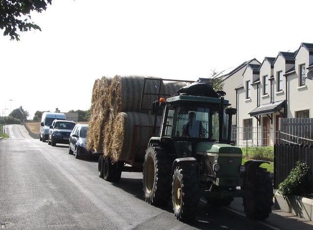

As always, the Chester County Weather Insider is ahead of the curve, bringing cutting edge coverage of stories that matter.  

Tuesday, January 19, 2016

Chester County in the Bulls-eye? Some Models Say Yes!

Chester County residents are bracing for what could be the biggest snow event of the season, making recent events look like trivial dustings...which they were.  This weekend things are in place for a winter storm to be named later to develop and ravage the mid-atlantic before heading up the east coast and developing into a Nor'Easter.

We at the Insider know it is hard to really take a winter storm seriously until it has a name.  But don't be lulled into complacency by the anonymity of this little low pressure devil.

As things set up, the two most reliable weather models show slightly different forecasts, but both spell significant snow for our region.

Sally, the US GFS Weather Model had this to say:


"Well, so far it's been like, uh, pretty mild, but now it's cold, and when that happens the rain we normally get freezes and becomes snow.  And I drew this map and I say the bulls-eye is like right here, to the west of philly."


Sally is predicting a total of 2-3 feet for our area, the highest of any place on the east coast.

Other models feel that the storm will be a little stronger to the south and west.


Ulf, our European model had this to say:

"Vee sink zee storm shall be more strong a bit to zee lower states.  Eet is in ziss areas zat zee totals will exceed 90 cm, or as you say 3 ft."


Even Ulf feels Chester County could see 12-18 inches.  Avongrove Schools have already scheduled an inservice day on Monday, so students can sled their way to stores and get any bread or eggs that their parents forgot to get Thursday.  "We consulted the Farmer's Almanac last year and knew we were in for a doozy," said Ernie Sneed, head of transportation.


Friday, December 25, 2015

Chester County Dreams of Wet Christmas

Christmas 2015 was one for the ages as old man spring reared his ugly head and blasted the region with mild temperatures and warm rain.

While the warm temperature was a blessing for many in the region who have lost weight reading the Insider Inc.'s health blog, "Newtritarian", it created some problems for Santa as he moved through the region.


Just south of the Poconos, our Weather Insider Santa Tracker picked up this troubled Santa at dawn.  However, within a short time some friendly elves in the Warm Weather Troubleshooting Division airlifted in a solution, and in a flash Santa was on his way again.


Santa was able to make his remaining stops in Chester County using this 2 wheleled sleigh, before ditching it when it ran out of gas as he crossed into Jersey.

This unusual Subtropic blast, referred to in serious weather circles as "La Piñata" gets its name from the warm temperatures associated with Cinco de Mayo and the way water dumps from the sky as if a giant Piñata has been bashed over our region.


Santa was able to deal with the warm weather and unusual amounts of water in style - here he is finishing up deliveries along the Black Horse Pike in nearby NJ, humming the beach boy classic "Little St. Nick" and making the most of this year's unusual circumstances.


We at the Insider would encourage you to be safe this holiday season. Check in on elderly neighbors and relatives to make sure none are in danger of heat stroke, and make sure they are staying hydrated.

La Piñata is expected to influence the region for at least a few more weeks.  We will have more updates when our weather models have new information.


Our current model seems to really have no idea what to expect.